
Basic info for the day
- Travel through the historic heart of Switzerland, from German-speaking Lucerne on the northern side of the Alps, through the Gotthard Massif to Lugano, the largest city in the Italian-speaking part of the country.
- Start the journey on a historic Lake Lucerne paddle steamer past the Rütli meadow, the 1291 "birthplace" of Switzerland; continue by train through the 15 km/9,3 mile old Gotthard tunnel.
- End in Lugano, the largest city in the Italian-speaking canton of Switzerland.
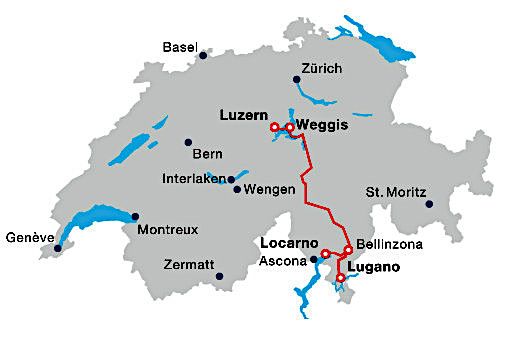
Route map for the day
Lake Lucerne
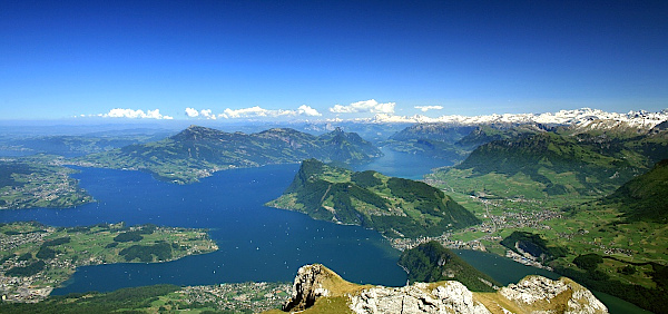
The actual name of the lake is Vierwaldstättersee, meaning the 'Lake of the Four Forest Cantons'.
Since 1837, the Lake Lucerne Navigation Company operates a fleet of paddle steamers and motoboats providing public transportation to 32 places along the shore. The time taken to travel from Lucerne to the end point at Flüelen is 2 hr7 min.
Key statistics:
- 4th largest lake in Switzerland
- Total area is 114 km (44 sq mi)
- Elevation is 434 m (1'424 ft) above sea level
- Depth at its deepest point is 214 m (702 ft)
- Volume is 11.8 km3
The Rütli Meadow - "Birthplace" of Switzerland
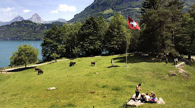
The Rütli is a beautiful, unspoiled mountain meadow on Lake Lucerne, only reachable on foot or by boat.
According to legend, it is the site where in 1291 the representatives from three cantons bordering the lake (Uri, Schwyz and Unterwalden) met in secret to swear the 'Eternal Alliance of the League of the Three Forest Cantons' or to come to each other's assistance in times of need but never to interfere in each other's affair; this is known as the "Rütlischwur" and marks the foundation of the original Swiss Confederacy.
In 1859, the Rütli meadow was bought by the Schweizerische Gemeinnützige Gesellschaft (SGG), the "Swiss Society for Public Utility", with the aim of preserving it as a site of national importance - mainly to prevent the building of a grand hotel at the site. Ownership of the site was then turned over to the Federal Government to hold it as an inalienable national property.
On July 25, 1940, General Henri Guisan gathered all his senior officers of the Swiss Armed Forces at the Rütli to give his famous speech, the "Rütlirapport", in which he outlined the Swiss Reduit strategy in the event of invasion by Germany and his aim never to surrender.
"I decided to reunite you in this historic place, the symbolic ground of our independence, to explain the urgency of the situation, and to speak of you as a soldier to soldiers. We are at a turning point of our history. The survival of Switzerland is at stake."
Since 1991, Rütli has been the start of the 35 km Swiss Path hiking trail around the lake created to celebrate the 700th anniversary of Switzerland.
See also: Swiss History
The Gotthard Route
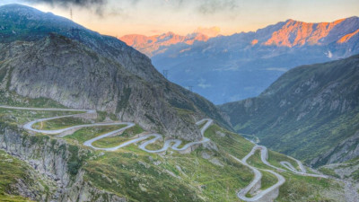
Historically the St Gotthard Massif area of the Alps formed a solid barrier between southern and northern Europe for centuries. To cross from north to south required a dangerous journey by mule, later horse drawn carriage over the high mountain pass which was only open in the summer months.
The building of a railway line through the Gotthard had an immediate and dramatic efect on the movement of goods and people. It is an incredible example of railway engineering and involves spiralling in and out of the mountains to reach a certain altitude to reach the Gotthard Tunnel underneath the highest point.
Read more here: The Gotthard - Legend, history, significance for Switzerland
Key info on LUGANO

Population - 64'000 in the city / 145'000 in greater Agglomeration; the largest city in Italian-speaking Ticino but not its capital city (that is Bellinzona)
Location - Strategic location around a sheltered bay on the northern side of Lake Lugano, 45 miles north of Milan, Italy, on a key North-South trade route through the Alps.
Climate - pleasant mild climate that allows many exotic trees and plants to flourish, best seen in the Parco Ciano.
History - Area inhabited since the Stone Age. Settled by Romans in 1st century BC. Subsequently a melting pot of European cultures - being variously under the domination of the Romans, Germanic tribes (Barbarians), Canton of Uri, Dukes of Lombardy, Dukes of Milan, Napoleon's forces, until it finally joined the Swiss Confederation in 1803.
Italian speakers - Largest city outside of Italy where Italian is the predominant language.
Eurovision - Lugano was the first host-city of the Eurovision Song Contest in 1956.
Lugano today: a financial, educational and conference centre :
- a financial/wealth management center - 3rd largest financial center after Zürich and Geneva
- a regional center for higher education - 3 universities and institutes for higher research focusing on supercomputing and artificial intelligence.
- a hub for conferences and a town for tourists with traffic-free historic centre and numerous buildings in Italianate Lombard style, beautiful parks, villas, 3 art museums, many sacred buildings and 2 mountain peaks

For more info, see also
- Swiss history
- The Gotthard - Legend, history, significance for Switzerland
- William Tell - Symbol of Switzerland for 700 years
- Typical Swiss Foods - Specialities from Ticino